
Precision Aerial Data Services
Five specialized aerial intelligence services engineered for construction, infrastructure, and energy sectors. From high-resolution topographic terrain modeling to thermal fault screening, every dataset we deliver is engineering-grade, georeferenced, and ready for integration into your CAD or GIS workflow.
Project-specific scope · Quote-based pricing
Service 01
Topographic Terrain Modeling
Our drone-based topographic terrain modeling produces high-resolution terrain data from high-overlap aerial imagery. Using RTK/PPK-enabled drone platforms and photogrammetric processing with ground control points, we generate orthomosaics, digital elevation models, and contour outputs that support grading design, drainage analysis, and site engineering.
Site engineers, civil designers, and land developers use these datasets to accelerate planning workflows. A 100-acre site can typically be captured in a single flight session and processed within the timeline agreed in your Statement of Work.
Every deliverable is georeferenced to your project coordinate system, includes documented methodology, and is QA-checked before release. Where a project requires certified survey output, we work alongside licensed surveyor partners.
Deliverables
- Georeferenced orthomosaic (GeoTIFF)
- Digital Elevation Model (GeoTIFF)
- Contour outputs (DXF/SHP)
- Topographic surface model
Applications
- Pre-construction site documentation
- Grading design support
- Drainage analysis
- Land development planning
Topographic terrain modeling is provided for planning and design support and is not a licensed land survey.
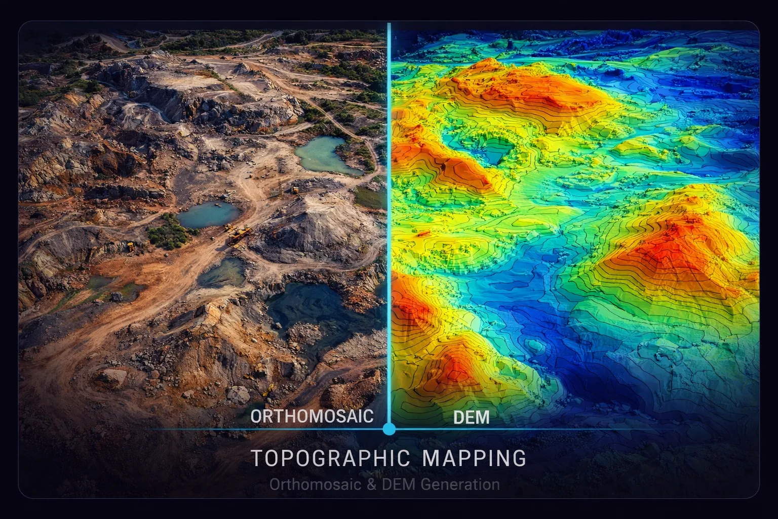
Topographic Terrain Modeling
Orthomosaic & DEM Generation
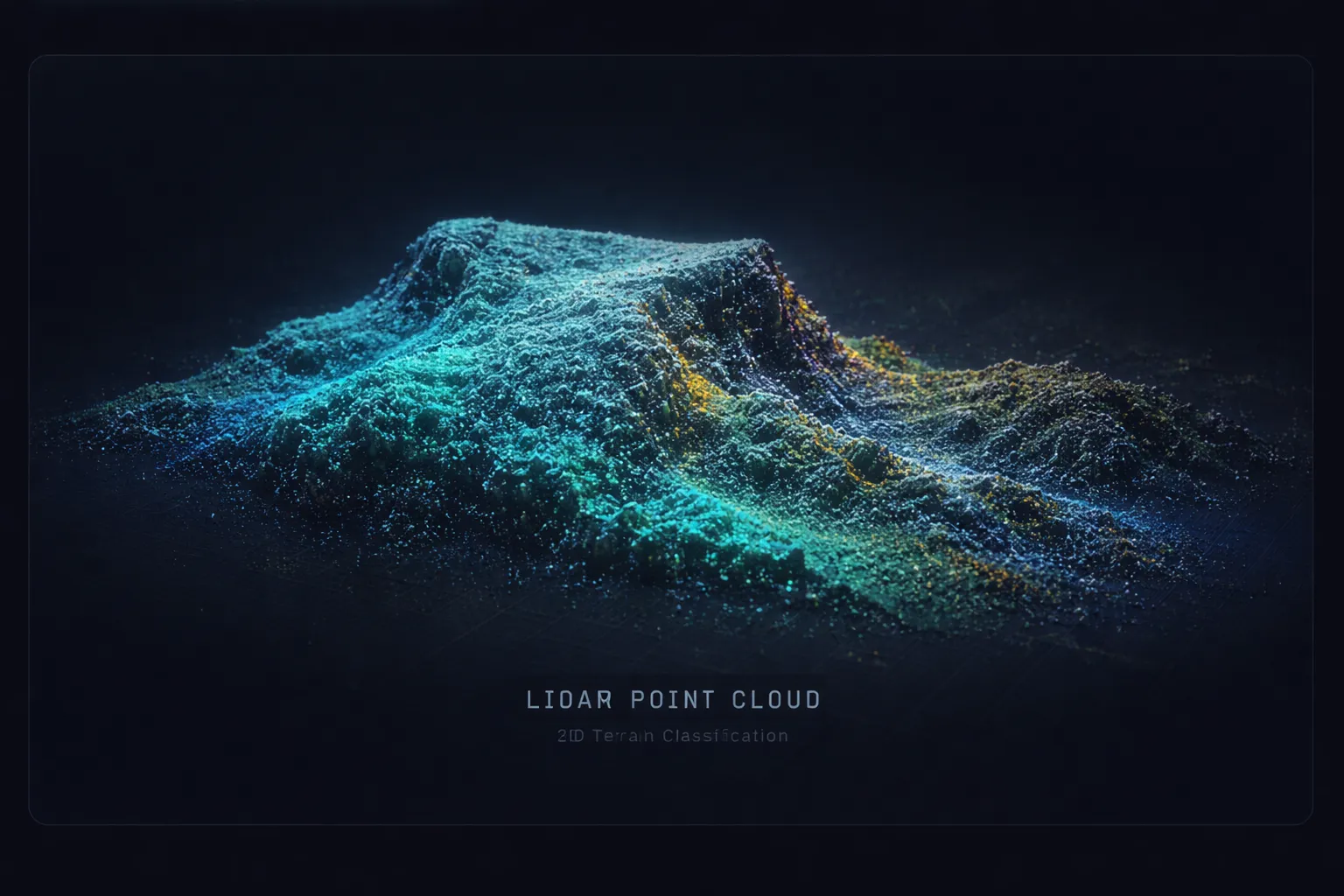
LiDAR Scanning
Classified Point Cloud Generation
Service 02
Core ServiceLiDAR Terrain Scanning
LiDAR scanning generates dense 3D point clouds where photogrammetry alone is not enough — under tree canopy, in low-contrast terrain, or where bare-earth modeling is the priority. Active laser pulses penetrate vegetation to capture the ground surface beneath, producing classified returns suitable for terrain, vegetation, and structure modeling.
Civil engineers, foresters, and corridor designers use LiDAR data when canopy or terrain complexity makes photogrammetry insufficient. Combined with our photogrammetric workflow, LiDAR provides a complementary dataset that fills gaps a camera cannot.
Output formats include classified LAS/LAZ point clouds, bare-earth digital terrain models, and canopy height models — all delivered in your project coordinate system.
Deliverables
- Classified point cloud (LAS / LAZ)
- Bare-earth digital terrain model
- Canopy height model
- Cross-section & profile exports
Applications
- Vegetated terrain modeling
- Corridor design support
- Forestry analysis
- Flood and drainage modeling
Service 03
Stockpile Volume Measurement
Accurate material inventory is the backbone of cost control in aggregate, mining, and bulk material operations. Our drone-based volumetric measurement captures the precise geometry of every stockpile on your site, producing volume calculations that are repeatable, auditable, and significantly faster than ground-based methods.
Operations managers, quantity professionals, and finance teams use the volume reports to reconcile supplier invoices, track inventory levels, and meet internal reporting requirements. Each pile is individually segmented, measured against a defined base surface, and documented with net volume, surface area, and peak height data.
For clients with recurring measurement needs, we offer monthly capture programs with comparative analysis showing material movement, gain/loss trends, and production reconciliation over time.
Deliverables
- Volume calculation reports (PDF)
- Stockpile surface models
- Per-pile segmented analysis
- Monthly comparison data
Applications
- Aggregate yards
- Mining operations
- Material tracking
- Internal volume reconciliation
Volumetric measurement is provided for inventory and operational reporting and is not a licensed land survey.
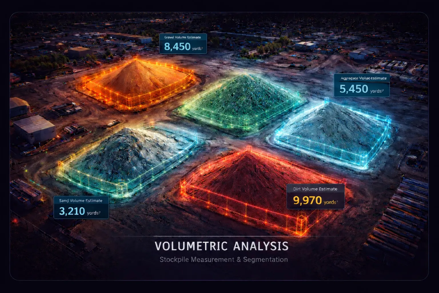
Volumetric Analysis
Stockpile Measurement & Segmentation
Progress Tracking
As-Built vs. Design Overlays
Service 04
Construction Site Monitoring
Periodic aerial monitoring provides a continuous visual and geospatial record of construction progress. By capturing high-resolution orthomosaics on a weekly or monthly schedule, we create time-series datasets that let project teams compare current conditions against design plans and previous captures.
General contractors, project managers, and owner representatives use these datasets to support earthwork tracking, document progress for pay applications, identify schedule deviations early, and maintain a defensible photographic record of site conditions throughout the project lifecycle.
Each monitoring session can include automated as-built versus design overlay generation, cut/fill volume tracking against planned grades, and deviation highlighting where actual conditions differ from design intent.
Deliverables
- Progress orthomosaics
- As-built vs. design overlays
- Cut/fill volume tracking
- Schedule-aligned visit reports
Applications
- Progress documentation
- Pay application support
- Schedule deviation tracking
- Site documentation archive
Service 05
Thermal Infrastructure Inspection
Radiometric thermal imaging surfaces electrical and mechanical anomalies before they show up in production data — overheating connections, failed bypass diodes, cell-level faults in PV modules, hot splices on transmission lines, and bearing temperature irregularities on rotating equipment.
Solar O&M teams, utility operators, and facility managers use thermal screening to triage maintenance, prioritize site visits by your line crews, and document equipment condition over time.
Every thermal anomaly is GPS-tagged, classified per IEC 62446-3 categories where applicable, and documented in a structured report ready for your work-order system. Critical-severity findings are flagged on a priority track per the timing agreed in your Statement of Work.
Deliverables
- Thermal anomaly report (PDF)
- GPS-tagged finding list (CSV / GeoJSON)
- RGB orthomosaic for visual reference
- Severity classification per anomaly
Applications
- Solar PV array inspection
- Transmission line screening
- Substation component review
- Building envelope review
Thermal screening identifies likely areas of interest based on infrared signatures. Final condition assessment and any electrical work require validation by a qualified electrician or O&M technician.
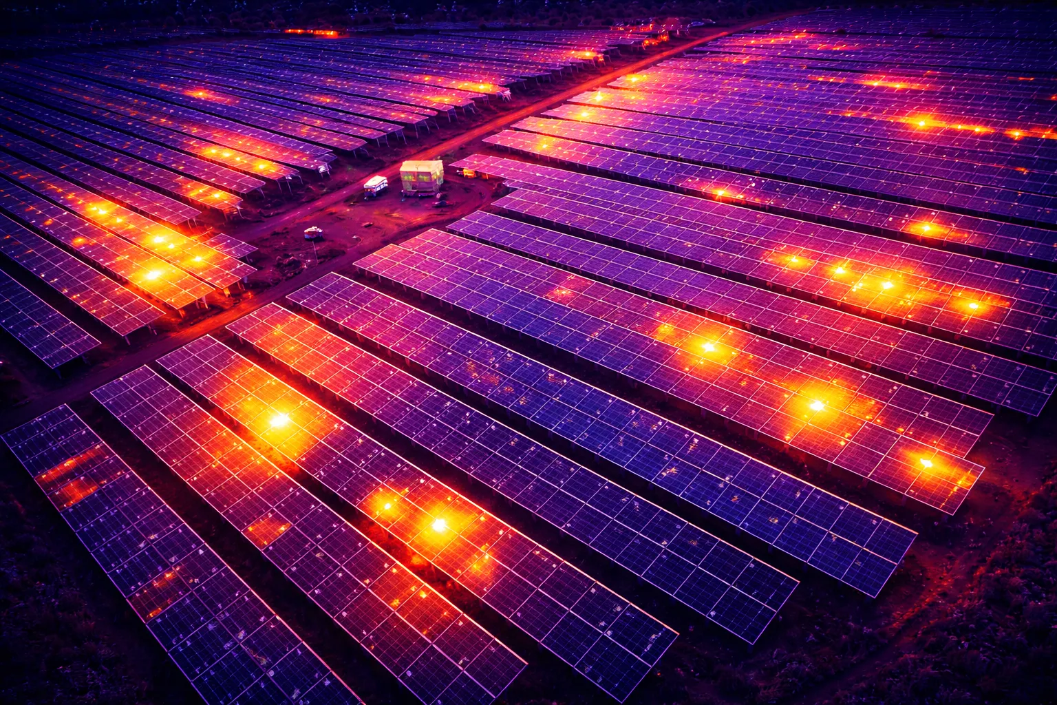
Thermal Inspection
Radiometric Anomaly Detection
RTK/PPK
Engineering-Grade Workflow
cm-class
GSD & Project Targets
SoW
Defined Turnaround
Quote
Project-Specific Pricing
Enterprise-Grade Operations
Professional Drone Platform
RTK/PPK-enabled drone platforms with weather-resistant builds for reliable commercial fieldwork.
LiDAR + Thermal Capability
Multi-sensor data capture in a single mobilization. High-density point clouds and calibrated radiometric thermal imaging.
GDPR-Compliant Workflows
All data processed and stored in compliance with EU data protection regulations. Secure delivery protocols.
Fully Insured Operations
Commercial liability insurance (Betriebshaftpflichtversicherung) covering all flight operations and data handling.
Structured Legal Framework
EASA-compliant operations, formal Angebot proposals, and AV-Vertrag data processing agreements for German clients.
Service & Scoping Questions
What equipment does SkyPlotter use?
How is pricing determined?
How accurate is drone LiDAR mapping?
What file formats do you deliver?
Do you offer recurring monitoring contracts?
Where does SkyPlotter operate?
Start Your Next Project
Tell us about your site, your timeline, and the deliverables you need. We'll scope the operation and deliver a written proposal.
Typical response · same business day